
Introduction
The City of Durham is setting a vision for several key transportation corridors in and near downtown Durham. Bike Durham is excited that the City is soliciting input on the future of these important streets. We believe the City should, in general, put people above cars in all of the designs. This means allocating precious street space to pedestrians, cyclists, and transit users. If you have limited time, please tell them that here.
However, the City is soliciting detailed feedback on proposed designs for each street. Bike Durham has developed the following guide for how to vote on each of the corridors. This information is based on our technical expertise about best practices that increase safety for multi-modal transportation options.
*Before you click the button, keep reading to get our recommendations.
The survey is open through August 31st, 2019.
Survey Directions

When you begin the survey, you’ll see a set of eight priority streets.
Click on the street you want to give input on, then scroll down to the survey link and click it to begin the survey. The first page of the survey asks how you currently use the street, how you’d like to use it, etc. For many of the streets, the second page of the survey divides the corridor into segments, and walks you through different design alternatives for each segment. Your choice for each design is:
I support this option
I DO NOT support this option
And then you are given a space to share your thoughts.
Our Recommendations
Click the following links to skip to that street:
Elizabeth/Fayetteville Street
Elizabeth Street: Ramseur to Holloway

Support Alternative 2: Landscaped Medians w/Turn Pockets + Pedestrian Refuge Islands
Alternative 1 and 2 both have protected bike lanes, which is Bike Durham’s highest priority—we’re advocating for a “low-stress network” (LSN) of such lanes. They would provide continuous protection from car traffic on key corridors, with as few interruptions of protection as possible, and they would connect to one another so people could ride safely and confidently from origin to destination. Alternative 2 features a median, which is important for pedestrians crossing the street: The presence of a median has been shown to reduce pedestrian crashes by 40%. And vertical elements in or next to roadways, like trees planted in medians, tend to reduce traffic speed, which results in fewer and less harmful collisions.
Fayetteville Street: Limited Access Transition (Highway 147 Overpass)
Support Phase I
Support Long Term Vision: Three Lanes with Buffered Bike Lanes and Wide Sidewalks
Fayetteville Street: Commercial (Umstead to Lakewood)

Support Phase I
Support Long Term Vision 3: Bus Lanes + High Frequency Transit, Curb-Separated Bike Lane, and Pedestrian Refuge Islands
Bike Durham advocates for increased transit accessibility and pedestrian amenities as well as bicycle-focused infrastructure. Alternative 1 has bus lanes without protected bike lanes. Alternative 2 is vice-versa. Alternative 3 is the best of all worlds: Bus lanes with stop improvements, and maximally protected bike paths. This is the sort of street plan we’d like to see everywhere the right-of-way width allows for it.
Fayetteville Street: Mixed Use, Residential, and Institutional (Cecil to Umstead)
Support Traffic Calming and Pedestrian Safety Treatment Examples
While it would be difficult to put bicycle infrastructure in this narrow roadway, Bike Durham would like the city to identify a parallel street or trail nearby to include in a low-stress network.
Duke/Gregson/Vickers Street
Residential, Mixed-Use, and Downtown (University to Club)

Support Alternative 3: Two-Way with Parking
Few cyclists dare to ride on Duke or Gregson because people tend to drive frighteningly fast on these two-lane, one-way streets. In this case, we forgo recommending bike lanes in order to protect drivers and pedestrians from the dangerously high speeds that the current one-way design enables. Two-way streets would significantly calm traffic in these residential neighborhoods, and cyclists can instead use parallel streets and greenways such as Watts Street and the American Tobacco Trail.
Alston Avenue/Avondale Drive
Avondale Drive: Residential, Mixed-Use, and Commercial (Alston to Knox)

Support Alternative 2: Multi-Use Path and Transit Amenities
We prefer Alternative 2 because the multi-use path separates bicycles from cars.
Alston Avenue: Residential, Mixed-Use, and Industrial (Holloway to Avondale)

Support Alternative 3: Bike Lanes and Transit Amenities, BUT need to add either protected bike lanes or a multi-use path
We think bike lanes are crucial for this key north-south corridor, but we don’t understand why this alternative doesn’t protect them. We urge the city to modify the design to protect the bike lanes.
Chapel Hill Street
Limited Access Road Transition (Shepherd to Gregson)

Support Alternative 3: Reduce Lanes, Buffered/Separated Bike Lanes, Wider Sidewalks
Alternative 2 and 3 are identical, save for the widths of the sidewalks and travel lanes. The narrower drive lanes in Alternative 3 would slow car traffic, which saves lives.
Downtown (Gregson to Ramseur)
Support Alternative 1: Streetscape Improvements, Buffered Bike Lanes
Commercial (Kent to Shepherd)

Support Alternative 2: Separated Bike Lanes
This is a simple choice between buffered and non-buffered bike lanes.
Downtown Loop
Morgan Street (Roxboro to Chapel Hill)

Support Alternative 1: Two-Way Conversion, Protected Bikeway
We strongly support the conversion of the downtown loop from a one-way to a two-way thoroughfare. There is little justification for the present one-way design; because the north-south streets that pass through it are heavily traveled, and thus prioritized by traffic signals, the loop hardly achieves the purpose of one-way streets, which is to move cars through quickly. Converting to two-way streets would calm traffic while making it less confusing to navigate downtown. Alternative 1 is the only one among these alternatives to include protected bike lanes. We would prefer Alternative 2 if they tweaked the design to buffer the bike lanes.
Ramseur Street (Chapel Hill to Roxboro)

Support Alternative 2: Two-Way Conversion, Bus Lane + High Frequency Transit, Shared Use Path
All three of these designs feature protected bikeways. We advocate for Alternative 2 because it includes a bus-only lane, which is well-suited to Ramseur Street.
Roxboro/Mangum Street
Residential/Mixed-Use (Corporation to Markham)

Support Alternative 1: One-Way w/Protected Bikeway
Our choice here would maximize bicycle safety with a fully curb-protected cycle track.
MangUm: Downtown (from Dillard to corporation)
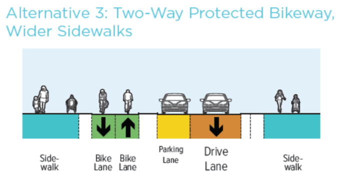
Support Alternative 3: Two-Way Protected Bikeway, Wider Sidewalks.
Our choice here would maximize bicycle safety with a fully curb-protected cycle track.
Roxboro: Downtown (Dillard to Elliott)
We don’t support any of these options. Alternative 1 is the least-bad because of the presence of the bike lane. However, placing a bike lane to the left of a parking lane with no buffer creates a car-door minefield. In the comments, please urge the city to come up with a better solution.
Holloway Street
Holloway Street and North Hyde Park Ave
Support Redesign
Holloway Street and Oakwood Ave
Support Version 1 or 2
We’re agnostic on these intersection designs. We want to see protected bike lanes on the west end of Holloway Street, between Roxboro and Dillard—if you like, you can note this in the comments.
Durham Freeway
Some points for you to add in the text box asking “What can be done to reconnect communities negatively impacted by construction of the Durham Freeway to other parts of the City?” could include: Better bike/ped access on the streets that cross the Durham Freeway.
The survey asks, “Did you know?” Many Durhamites do know that when the Durham Freeway was built, it tore through the heart of Hayti and other central neighborhoods, displacing homes, businesses, and churches, and cutting parts of the city off from one another. While it’s too late to fully reverse the damage done, the city could benefit greatly from converting the highway to a surface street. With the East End Connector set to open in 2020, many of the freeway’s current users will have better options for moving through the city, and the imminent need to repair many of the bridges that pass over it presents the city with a unique opportunity to make a bold, epochal change before it continues throwing good money after bad. A persuasive accounting of the reasons why we advocate for the freeway’s removal can be found in this News & Observer opinion piece, written in 2016 by Bike Durham member and advisor Erik Landfried.